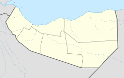
Dabaqabad
Appearance
Coordinates: Template:Xb_type:city 8°41′0″N 45°49′0″E / 8.68333°N 45.81667°E
Dabaqabad | |
|---|---|
Village | |
| Coordinates: Template:Xb_type:city 8°41′0″N 45°49′0″E / 8.68333°N 45.81667°E | |
| Country | |
| Region | Togdheer |
| District | Burao District |
| Time zone | UTC+3 (EAT) |
Dabaqabad, or Daba Qabad is a village in Burao District, in the Togdheer Region of Somaliland. It is located north by road from Balidhiig.[1][2]
References
- ^ "Daba Qabad Map | Somalia Google Satellite Maps". www.maplandia.com.
- ^ "DABA QABAD TOGDHEER SOMALIA Geography Population Map cities coordinates location - Tageo.com". www.tageo.com.

