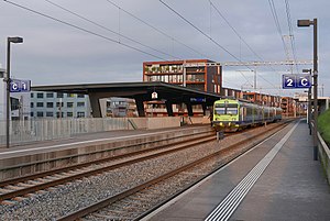
Bern Brünnen Westside railway station
Appearance
Bern Brünnen Westside | |||||||||||||||||||
|---|---|---|---|---|---|---|---|---|---|---|---|---|---|---|---|---|---|---|---|
 A BLS train arrives at the station in 2016 | |||||||||||||||||||
| General information | |||||||||||||||||||
| Location | Bern Switzerland | ||||||||||||||||||
| Coordinates | 46°56′38.533″N 7°22′31.001″E / 46.94403694°N 7.37527806°E | ||||||||||||||||||
| Elevation | 558 m (1,831 ft) | ||||||||||||||||||
| Owned by | BLS AG | ||||||||||||||||||
| Line(s) | Bern–Neuchâtel line | ||||||||||||||||||
| Distance | 5.3 km (3.3 mi) from Bern[1] | ||||||||||||||||||
| Train operators | BLS AG | ||||||||||||||||||
| Connections |
| ||||||||||||||||||
| Other information | |||||||||||||||||||
| Fare zone | 101 (Libero)[3] | ||||||||||||||||||
| Services | |||||||||||||||||||
| |||||||||||||||||||
| |||||||||||||||||||
Bern Brünnen Westside railway station (Template:Lang-de) is a railway station in the municipality of Bern, in the Swiss canton of Bern. It is an intermediate stop on the standard gauge Bern–Neuchâtel line of BLS AG.[1]
Services
As of the December 2020 timetable change,[update] the following services stop at Bern Brünnen Westside:[4]
References
- ^ a b Eisenbahnatlas Schweiz. Cologne: Schweers + Wall. 2012. p. 66. ISBN 978-3-89494-130-7.
- ^ "Liniennetz Bern" (PDF) (in German). Libero. 13 December 2020. Retrieved 3 January 2021.
- ^ "Zonenplan" (PDF) (in German). Libero. 13 December 2020. Retrieved 3 January 2021.
- ^ "Neuchâtel - Ins - Kerzers - Bern (S-Bahn Bern, Linien S5, S51, S52)" (PDF) (in German). Bundesamt für Verkehr. 23 November 2020. Retrieved 3 January 2021.
External links
 Media related to Bern Brünnen Westside railway station at Wikimedia Commons
- Bern Brünnen Westside railway station – SBB

