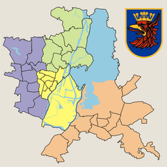
Zachód, Szczecin
Appearance
Zachód | |
|---|---|
District | |
 | |
 | |
| Country | |
| Voivodeship | West Pomeranian |
| County/City | Szczecin |
| Population (2011) | |
| • Total | 116,232 |
| Time zone | UTC+1 (CET) |
| • Summer (DST) | UTC+2 (CEST) |
| Area code | +48 91 |
| Car plates | ZS |

Zachód
Zachód (lit. West) is one of four districts (Polish: dzielnica) of Szczecin, Poland situated on the left bank of Oder river in western part of the city. As of January 2011 it had a population of 116,232.[1]
Zachód is divided into 9 municipal neighbourhoods:
- Arkońskie-Niemierzyn
- Głębokie-Pilchowo
- Gumieńce
- Krzekowo-Bezrzecze
- Osów
- Pogodno
- Pomorzany
- Świerczewo
- Zawadzkiego-Klonowica
References
[edit]- ^ "Zestawienie informacyjne o liczbie osób zameldowanych w Szczecinie" (in Polish). Urząd Miasta Szczecin. Retrieved 2011-01-23.
53°26′24″N 14°29′50″E / 53.4399°N 14.4972°E

