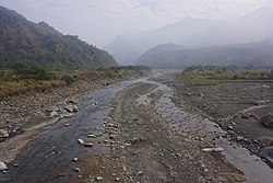
Qishan River
Appearance
| Qishan River | |
|---|---|
 | |
| Location | |
| Country | Taiwan |
| Physical characteristics | |
| Mouth | |
• location | Ligang/Cishan |
• coordinates | 22°49′55″N 120°28′01″E / 22.832°N 120.467°E |
| Length | 117 km (73 mi) |
| Basin size | 842 km2 (325 sq mi) |
| Discharge | |
| • location | Nanfeng Bridge |
| • average | 30 m3/s (1,100 cu ft/s) |
| • minimum | 0.1 m3/s (3.5 cu ft/s) |
| • maximum | 1,298 m3/s (45,800 cu ft/s) |
| Basin features | |
| River system | Gaoping River |

The Qishan River (Chinese: 旗山溪; Hanyu Pinyin: Qíshān Xī; Tongyong Pinyin: Císhan Si; Wade–Giles: Ch'i2-shan1 Hsi1)[1] or Nanzixian River (Chinese: 楠梓仙溪; Hanyu Pinyin: Nánzǐxian Xī; Tongyong Pinyin: Nánzǐhsian Si; Wade–Giles: Nan2-tzu3-hsien5 Hsi1)[2] is a tributary of the Gaoping River in Taiwan.[3] It flows through Chiayi County, Kaohsiung City, and Pingtung County for 117 km.[4]
Bridges
[edit]See also
[edit]References
[edit]- ^ "GeoNames Search". Geographic Names Database. National Geospatial-Intelligence Agency, USA. Retrieved 10 June 2016.
- ^ "《那瑪夏耆老說故事》楠梓仙溪 原名男子仙溪". Liberty Times Net (in Chinese (Taiwan)). 1 May 2014. Retrieved 10 June 2016.
- ^ "Gaoping River" (in Chinese). Water Resources Agency, Ministry of Economic Affairs. Archived from the original on 4 March 2016. Retrieved 10 June 2016.
- ^ "98年高屏溪流域管理工作執行年報" (PDF) (in Chinese (Taiwan)). Gaoping River Basin Management Committee. October 2010. Retrieved 10 June 2016.

