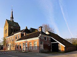
't Zandt
Appearance
't Zandt | |
|---|---|
 't Zandt in 2011 | |
Location of 't Zandt in the province of Groningen | |
| Coordinates: 53°21′57″N 6°46′28″E / 53.36583°N 6.77444°E | |
| Country | Netherlands |
| Province | Groningen |
| Municipality | Eemsdelta |
| Population (1 January 2006) | 867 |
- 't Zandt should not be confused with villages named 't Zand.
't Zandt (Dutch pronunciation: [ət ˈsɑnt])[1] is a village in the Dutch province of Groningen. It is located in the municipality of Eemsdelta.
't Zandt was a separate municipality until 1990, when it was merged with Loppersum.[2] The municipality covered the villages 't Zandt, Zeerijp, Leermens, Eenum and Oosterwijwerd, and the hamlets Zijldijk, Kolhol, Korendijk and 't Zandstervoorwerk.[3]
References
- ^ In isolation, Zandt is pronounced [ˈzɑnt].
- ^ Ad van der Meer and Onno Boonstra, Repertorium van Nederlandse gemeenten, KNAW, 2011.
- ^ Abraham Jacob van der Aa, "Aardrijkskundig woordenboek der Nederlanden", vol. 1 (A), 1839.
External links
- Template:Kuyper Map of the former municipality, around 1868.
 Media related to 't Zandt at Wikimedia Commons
53°22′0″N 6°46′40″E / 53.36667°N 6.77778°E

