
Search results
The page "Ordnance map" does not exist. You can create a draft and submit it for review or request that a redirect be created, but consider checking the search results below to see whether the topic is already covered.
 The Ordnance Survey (OS) is the national mapping agency for Great Britain. The agency's name indicates its original military purpose (see ordnance and...84 KB (8,586 words) - 11:09, 12 July 2024
 in maps based on those surveys, whether published by the Ordnance Survey or by commercial map producers. Grid references are also commonly quoted in other...20 KB (2,197 words) - 13:36, 28 July 2024
 An ordnance datum (OD) is a vertical datum used by an ordnance survey as the basis for deriving altitudes on maps. A spot height may be expressed as above...7 KB (777 words) - 03:21, 14 July 2024
- the basis for deriving altitudes on maps Ordnance Survey, the national mapping agency for Great Britain Ordnance Corps (disambiguation) This disambiguation...723 bytes (106 words) - 01:45, 23 May 2023
 mislabeled as an Ordnance Survey map; in fact none of the officers worked for the Ordnance Survey, which was a separate organization. The Ordnance Survey of...13 KB (1,517 words) - 06:50, 25 March 2024
 itself is an online map, geodata search engine and editor. OpenStreetMap was created by Steve Coast in response to the Ordnance Survey, the United Kingdom's...67 KB (5,944 words) - 12:33, 2 August 2024
 schoolroom with its dark blue and gold embossed wallpaper.: p530 The Ordnance map to the right shows Ashfield surrounded by similar villa houses, each...11 KB (1,346 words) - 16:34, 21 November 2023
- The Ordnance Survey Great Britain County Series maps were produced from the 1840s to the 1890s by the Ordnance Survey, with revisions published until the...48 KB (1,262 words) - 21:12, 7 December 2023
- The OS MasterMap is the premier digital product of the Ordnance Survey. It was launched in November 2001. It is a database that records every fixed feature...7 KB (829 words) - 23:10, 2 July 2024
 Cadastral map Climatic map Geologic map Historical map Linguistic map Nautical map Physical map Political map Relief map Resource map Road map Star map Street...35 KB (4,296 words) - 16:10, 4 August 2024
 the United Kingdom's Ordnance Survey). As such, elevation information was of vital importance. As they evolved, topographic map series became a national...20 KB (2,043 words) - 12:03, 1 July 2024
- long-serving Director-General of the Ordnance Survey in Great Britain, was the first to suggest that the Ordnance Survey be used to map Ireland. A highly detailed...13 KB (1,455 words) - 19:56, 21 May 2024
 seen in early ordnance survey maps. Ordnance Survey: Landranger map sheet 91 Appleby-in-Westmorland (Brough & Kirkby Stephen) (Map). Ordnance Survey. 2014...1 KB (90 words) - 13:56, 6 April 2021
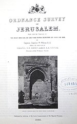 The Ordnance Survey of Jerusalem of 1864–65 was the first scientific mapping of Jerusalem, and the first Ordnance Survey to take place outside the United...12 KB (1,579 words) - 17:18, 17 February 2023
 Unexploded ordnance (UXO, sometimes abbreviated as UO), unexploded bombs (UXBs), and explosive remnants of war (ERW or ERoW) are explosive weapons (bombs...123 KB (13,654 words) - 21:13, 3 August 2024
- the west of the Airy meridian marked at Greenwich. When the first Ordnance Survey map was published in 1801, the official Prime Meridian of Great Britain...1,019 bytes (116 words) - 02:20, 11 February 2022
- William Roy (redirect from The Duke of Cumberland's Map)usually referred to as Roy's Map of Scotland. It was Roy's advocacy and leadership that led to the creation of the Ordnance Survey in 1791, the year after...39 KB (4,682 words) - 16:43, 11 December 2023
 Hartlepool on the A1086 road. Ordnance Survey: Landranger map sheet 93 Middlesbrough (Darlington & Hartlepool) (Map). Ordnance Survey. 2010. ISBN 9780319228777...1 KB (51 words) - 14:25, 25 July 2023
 the 1:50000 ordnance map this is rounded to 294 m. Dorking, Reigate and Crawley area (Map) (10GSGS ed.). 1:50000. Landranger 187. Ordnance Survey. 1991...16 KB (1,658 words) - 09:34, 25 August 2023
 Projected coordinate system (redirect from Map Reference)36174). The Ordnance Survey National Grid (United Kingdom) and other national grid systems use similar approaches. In Ordnance Survey maps, each Easting...21 KB (2,803 words) - 22:28, 19 June 2024


- article on: Ordnance Survey Wikipedia Ordnance Survey map (plural Ordnance Survey maps) any of a large series of high quality, detailed maps of Great Britain
- British 1 in. ordnance map the roads appear as if they were 130 ft. in width. Chorographical (Gr. χώρα, country or region) and general maps are either reduced
- balls right out of the park. Sgt. Frank Tree: You shouldn't touch the ordnance at all. But more specifically, you should never pull this hand-operating
- overarching, easily-understandable goal. Existing things such as Ordnance Survey maps can serve as a tangible model of the goal, even though the content