
Corcubión
Concello de Corcubión | |
|---|---|
municipality | |
 | |
 Seal | |
| Nickname: Corcubión | |
 Location of Corcubión within Galicia | |
| Area | |
| • Total | 6.58 km2 (2.54 sq mi) |
| Population (2018)[1] | |
| • Total | 1,578 |
| • Density | 240/km2 (620/sq mi) |
| Time zone | UTC+1 (CET) |
| • Summer (DST) | UTC+2 (CEST) |
| Website | www.corcubion.info/en |
Corcubión, or Corcubiom in the AGAL orthography of the Galician language, is a municipality of northwestern Spain in the Province of A Coruña, in the autonomous community of Galicia. The local government of the municipality was the first public institution to officially use the AGAL norm of the Galician language according to the Reintegrationism ideas, as seen in its website, offering options for "Galician" (NOMIGa) and "Galician-Portuguese" (AGAL), as well as English and Spanish.
It is located on the river with the same name.

History
Corcubión belonged to the county of Traba, but later passed into the hands of the Count of Altamira.
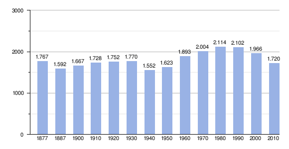
Demography
References
Official Website City Council of Corcubion
| International | |
|---|---|
| National | |
42°57′N 9°11′W / 42.950°N 9.183°W
This article about a location in the autonomous community of Galicia, Spain is a stub. You can help Wikipedia by expanding it. |
- ^ Municipal Register of Spain 2018. National Statistics Institute.