
Geography of Vojvodina


Vojvodina is an autonomous region within Serbia located in the Pannonian plain, a region of central Europe. It shares borders with Romania in the east, Hungary in the north, Croatia in the west, and Bosnia and Herzegovina in the southwest. The southern border is administrative line to Šumadija and Western Serbia, Belgrade, and Southern and Eastern Serbia.
Geographical regions of Vojvodina
Mountains and hills
Sands
Rivers
Canals
- Canal Danube-Tisa-Danube, and some larger canals part of DTD system:
Lakes and bogs
Gallery
-
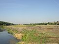 A landscape from Vojvodina, near the village of Skorenovac
 -

-

-
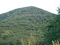 The highest point in Vojvodina
 -
 Typical plains landscape of Vojvodina


External links
Wikimedia Commons has media related to Geography of Vojvodina.