
Lemaire Channel

Lemaire Channel is a strait off Antarctica, between Kiev Peninsula in the mainland's Graham Land and Booth Island. Nicknamed "Kodak Gap" by some, it is one of the top tourist destinations in Antarctica; steep cliffs hem in the iceberg-filled passage, which is 11 km long and just 1,600 metres wide at its narrowest point.
It was first seen by the German expedition of 1873-74, but not traversed until December 1898, when the Belgica of the Belgian Antarctic Expedition passed through. Expedition leader Adrien de Gerlache named it for Charles Lemaire (1863-1925), a Belgian explorer of the Congo.
The channel has since become a standard part of the itinerary for cruising in Antarctica; not only is it scenic, but the protected waters are usually as still as a lake, a rare occurrence in the storm-wracked southern seas, and the north-south traverse delivers vessels close to Petermann Island for landings. The principal difficulty is that icebergs may fill the channel, especially in early season, obliging a ship to backtrack and go around the outside of Booth Island to reach Petermann.
-
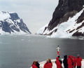 In the north entry of Lemaire Channel looking south, from the deck of the Hanseatic.
 -
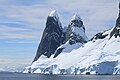
 Glaciers and cliffs reflected in still waters at the south end of the channel.
 -
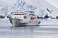 Russian cruise ship Akademik Sergey Vavilov in the Lemaire Channel
 -
-
 Icebergs in the channel


