Lenzerheide


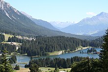
Lenzerheide (Romansh: Lai) is a mountain resort in the canton of Graubünden, Switzerland at the foot of the Parpaner Rothorn. The village lies in the municipality Vaz/Obervaz in the district of Albula, sub-district Alvaschein.
The village lies in a broadened section of the valley between the cantonal capital Chur to the north and Tiefencastel, beyond which are the Julier Pass and St Moritz. The high valley forms a pass of no official name, often referred to as Lenzerheide Pass, with a culmination point located 5 km north of the village.
Lenzerheide is popular as skiing resort and for its lake (Heidsee), which is frozen in winter. The Lenzerheide Bergbahnen AG offers access to the skiing areas of Stätzerhorn, Danis, Scalottas, and Rothorn.[1] There are slopes approved for all FIS Alpine Ski World Cup races for women and men.
At the end of 2013 the Lenzerheide ski resort was linked with Arosa by cable-car, creating the new ski resort of Arosa Lenzerheide. Since then transport passes are available to both resorts.
A two-day hike connects Lenzerheide with two more resorts in Graubünden in different Valleys, which are Arosa (can be reached in one day) and Davos (a two-day hike).[2]
Historical note
On 31 July 1954, Antoinette, Crown Princess of Bavaria, wife of Rupprecht, Crown Prince of Bavaria, died in Lenzerheide.
Sports
Lenzerheide has hosted several stages of the Tour de Ski, a cross-country skiing stage event. It was host to the 2018 UCI Mountain Bike World Championships, and is a stop in the 2019 UCI MTB World Cup tour.
References
- ^ Switzerland Ski Resort Lenzerheide, Graubünden (in English)
- ^ (in English) Hiking Alps in Switzerland, Lenzerheide, Graubünden Archived 2015-05-14 at the Wayback Machine
External links
![]() Lenzerheide travel guide from Wikivoyage
Lenzerheide travel guide from Wikivoyage
- Website of tourist office of Lenzerheide
- The municipality of Vaz/Obervaz (in German)
- Toni Cantieni: Lenzerheide/Valbella in German, French and Italian in the online Historical Dictionary of Switzerland.
