
Pleistos
| Pleistos (Πλείστος) | |
|---|---|
 | |
| Location | |
| Country | Greece |
| Physical characteristics | |
| Source | |
| • location | Mount Parnassus |
| Mouth | |
• location | Gulf of Corinth at Kirra |
• coordinates | 38°25′42″N 22°27′13″E / 38.4282°N 22.4535°E |
| Length | approx. 25–30 km (16–19 mi) |
The Pleistos (Greek: Πλείστος ή Πλειστός, Latin: Pleistus) is a river in central Greece. It rises at Mount Parnassos near the town Arachova, Boeotia. It flows west through a deep valley, between the mountains Parnassos and Kirphe, passing south of Delphi, through the Delphic Landscape and the plain of Amphissa and flows into the Corinthian Gulf near Kirra. The water of the Castalian Spring flow into Pleistos.
Historical information
Solon of Athens is said to have used hellebore roots to poison the water in an aqueduct leading from the River Pleistos around 590 BC during the siege of Kirrha.[1] The river Pleistos was also mentioned by the ancient geographers Strabo[2] and Pausanias.[3] Nowadays, the river has water mainly in the winter, whereas in the summer it dries out.
There is a hiking path along the river from Kirra to Delphi.[4]
Gallery
-
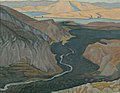 Painting of the Pleistos valley
 -
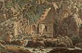 Painting of the Kastalian Spring.


References
- ^ Adrienne Mayor, "Greek Fire, Poison Arrows & Scorpion Bombs: Biological and Chemical Warfare in the Ancient World" Overlook-Duckworth, 2003, rev ed with new Introduction 2008
- ^ Strabo, Geographica, Book IX, Chapter 3
- ^ Pausanias, Description of Greece 10.8.8
- ^ Delphi, pathway (in Greek)
This Central Greece location article is a stub. You can help Wikipedia by expanding it. |
This article related to a river in Greece is a stub. You can help Wikipedia by expanding it. |