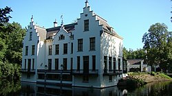
Staverden
Staverden | |
|---|---|
Village | |
 | |
| Coordinates: 52°17′11″N 5°44′17″E / 52.28639°N 5.73806°E | |
| Country | Netherlands |
| Province | Gelderland |
| Municipality | Ermelo |
| Population (2016[1]) | 30 |
| • Density | 13/km2 (30/sq mi) |
Staverden is a village in the Dutch province of Gelderland. It is located in the municipality of Ermelo, about 5 kilometres east of Ermelo.[2] It received city rights in 1298. With 30 inhabitants,[3] it is today the smallest place with that traditional title in the Netherlands. It is also officially the smallest city in the Benelux region.[4]
References
![]() Media related to Staverden at Wikimedia Commons
Media related to Staverden at Wikimedia Commons
- ^ http://statline.cbs.nl/Statweb/publication/?DM=SLNL&PA=83487ned&D1=0-1,3-4,11,31,33-35,77,80,90,93,99,101,104&D2=4935&VW=T
- ^ ANWB Topografische Atlas Nederland, Topografische Dienst and ANWB, 2005.
- ^ http://statline.cbs.nl/Statweb/publication/?DM=SLNL&PA=83487ned&D1=0-1,3-4,11,31,33-35,77,80,90,93,99,101,104&D2=4935&VW=T
- ^ http://beleefstaverden.nl/de-kleinste-stad/de-kleinste-stad
52°17′N 5°44′E / 52.283°N 5.733°E
