
Tunsel
Tunsel | |
|---|---|
Ortsteil of Bad Krozingen | |
 Coat of arms | |
Location of Tunsel  | |
 Tunsel  Tunsel | |
| Coordinates: 47°54′12″N 7°40′11″E / 47.90333°N 7.66972°E | |
| Country | Germany |
| State | Baden-Württemberg |
| Admin. region | Freiburg |
| District | Breisgau-Hochschwarzwald |
| Town | Bad Krozingen |
| Government | |
| • Local representative | Peter Ritzel (CDU) |
| Area | |
| • Total | 9.21 km2 (3.56 sq mi) |
| Elevation | 223 m (732 ft) |
| Population (2018-02-01[1]) | |
| • Total | 1,987 |
| • Density | 220/km2 (560/sq mi) |
| Time zone | UTC+01:00 (CET) |
| • Summer (DST) | UTC+02:00 (CEST) |
| Postal codes | 79189 |
| Dialling codes | 07633 |
| Vehicle registration | FR |
Tunsel is a village in the district of Breisgau-Hochschwarzwald in Baden-Württemberg. Since January 1974, it is an Ortsteil of Bad Krozingen.[2]
Gallery
-
 St. Michael Church
 -
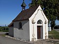 Maria-Hilf Kapelle (Our Lady Help of Christians Chapel)
 -
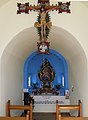 Inside Maria-Hilf Kapelle


References
- ^ Stadt Bad Krozingen. "Zahlen und Fakten" (in German). Archived from the original on 2018-03-17. Retrieved 2018-03-17.
- ^ Stadt Bad Krozingen. "Ortsteil Tunsel" (in German). Archived from the original on 2018-03-17. Retrieved 2018-03-17.
Districts of Bad Krozingen | ||
|---|---|---|
|  | |
This Breisgau-Hochschwarzwald location article is a stub. You can help Wikipedia by expanding it. |