Ağacanlı
Ağacanlı | |
|---|---|
Municipality | |
| Coordinates: 39°59′00″N 48°50′56″E / 39.98333°N 48.84889°E | |
| Country | |
| Rayon | Hajigabul |
| Population | |
| • Total | 351 |
| Time zone | UTC+4 (AZT) |
| • Summer (DST) | UTC+5 (AZT) |
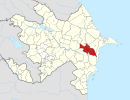
Ağacanlı (also, Agadzhanly) is a village and municipality in the Hajigabul Rayon of Azerbaijan. It has a population of 351.
References
Ağacanlı is the native name for the area . the alternative name for this area is Agacanli.This geographical location for agacanli is Azerbaijan, Asia.


