
Aberfoil, Alabama
Aberfoil, Alabama | |
|---|---|
 Aberfoil, Alabama  Aberfoil, Alabama | |
| Coordinates: 32°04′15″N 85°41′16″W / 32.07083°N 85.68778°W | |
| Country | United States |
| State | Alabama |
| County | Bullock |
| Elevation | 564 ft (172 m) |
| Time zone | UTC-6 (Central (CST)) |
| • Summer (DST) | UTC-5 (CDT) |
| Area code | 334 |
| GNIS feature ID | 112891[1] |
Aberfoil is an unincorporated community in Bullock County, in the U.S. state of Alabama. The main roads through the community are U.S. Route 29 and Alabama State Route 239.
History
A post office was established at Aberfoil in 1837, and remained in operation until it was discontinued in 1905.[2] A scene of the novel Rob Roy set in Aberfoyle, Scotland, likely inspired the naming.[3]
References
- ^ "Aberfoil". Geographic Names Information System. United States Geological Survey, United States Department of the Interior.
- ^ "Bullock County". Jim Forte Postal History. Archived from the original on 29 November 2014. Retrieved 9 February 2015.
{{cite web}}: Unknown parameter|deadurl=ignored (|url-status=suggested) (help) - ^ Foscue, Virginia O. (1989). Place Names in Alabama. University of Alabama Press. p. 5. ISBN 978-0-8173-0410-2.
Municipalities and communities of Bullock County, Alabama, United States | ||
|---|---|---|
| Cities | 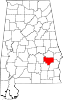 | |
| Towns | ||
| CDP | ||
| Unincorporated communities | ||
| Ghost towns | ||
This Alabama state location article is a stub. You can help Wikipedia by expanding it. |