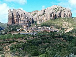
Agüero, Huesca
Appearance
Agüero | |
|---|---|
municipality | |
 | |
| Country | Spain |
| Autonomous community | Aragon |
| Province | Huesca |
| Comarca | Hoya de Huesca/Plana de Uesca |
| Area | |
| • Total | 94.16 km2 (36.36 sq mi) |
| Elevation | 696 m (2,283 ft) |
| Population (2009) | |
| • Total | 166 |
| • Density | 11.8/km2 (31/sq mi) |
| Time zone | UTC+1 (CET) |
| • Summer (DST) | UTC+2 (CEST) |
Agüero is a municipality located in the province of Huesca, Aragon, Spain. Its Postal Code is 22808.
The Mallos de Agüero rock formations rise above the town giving it a picturesque look.
Bibliography
- Antonio Ubieto Arteta, "Historia de Aragón". Los pueblos y los despoblados 1 (Ed. Anubar. Zaragoza, 1984)
External links
42°21′23″N 0°47′35″W / 42.35639°N 0.79306°W


