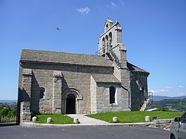
Albaret-Sainte-Marie
Appearance
Albaret-Sainte-Marie | |
|---|---|
 The church of Albaret | |
| Country | France |
| Region | Occitania |
| Department | Lozère |
| Arrondissement | Mende |
| Canton | Saint-Chély-d'Apcher |
| Intercommunality | Terres d'Apcher |
| Government | |
| • Mayor (2008–2014) | Michel Therond |
Area 1 | 15.98 km2 (6.17 sq mi) |
| Population (2209) | 556 |
| • Density | 35/km2 (90/sq mi) |
| Time zone | UTC+01:00 (CET) |
| • Summer (DST) | UTC+02:00 (CEST) |
| INSEE/Postal code | 48002 /48200 |
| Elevation | 767–1,139 m (2,516–3,737 ft) (avg. 970 m or 3,180 ft) |
| 1 French Land Register data, which excludes lakes, ponds, glaciers > 1 km2 (0.386 sq mi or 247 acres) and river estuaries. | |
Albaret-Sainte-Marie is a commune in the Lozère department in southern France.
Population
| Year | Pop. | ±% |
|---|---|---|
| 1793 | 478 | — |
| 1800 | 387 | −19.0% |
| 1806 | 615 | +58.9% |
| 1821 | 549 | −10.7% |
| 1831 | 502 | −8.6% |
| 1836 | 490 | −2.4% |
| 1841 | 528 | +7.8% |
| 1846 | 533 | +0.9% |
| 1851 | 479 | −10.1% |
| 1856 | 473 | −1.3% |
| 1861 | 406 | −14.2% |
| 1866 | 440 | +8.4% |
| 1872 | 434 | −1.4% |
| 1876 | 490 | +12.9% |
| 1881 | 541 | +10.4% |
| 1886 | 540 | −0.2% |
| 1891 | 502 | −7.0% |
| 1896 | 503 | +0.2% |
| 1901 | 469 | −6.8% |
| 1906 | 471 | +0.4% |
| 1911 | 501 | +6.4% |
| 1921 | 468 | −6.6% |
| 1926 | 442 | −5.6% |
| 1931 | 413 | −6.6% |
| 1936 | 426 | +3.1% |
| 1946 | 387 | −9.2% |
| 1954 | 374 | −3.4% |
| 1962 | 363 | −2.9% |
| 1968 | 320 | −11.8% |
| 1975 | 309 | −3.4% |
| 1982 | 333 | +7.8% |
| 1990 | 338 | +1.5% |
| 1999 | 452 | +33.7% |
| 2006 | 522 | +15.5% |
| 2009 | 556 | +6.5% |
See also
References
External links
Wikimedia Commons has media related to Albaret-Sainte-Marie.

