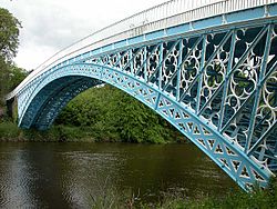
Aldford Iron Bridge
Appearance
Aldford Iron Bridge | |
|---|---|
 | |
| Coordinates | 53°08′05″N 2°52′15″W / 53.1347°N 2.8708°W |
| Crosses | River Dee |
| Locale | Aldford, Cheshire |
| Heritage status | Grade I |
| Characteristics | |
| Design | Arch bridge |
| Material | Iron |
| History | |
| Architect | Thomas Telford |
| Constructed by | William Hazledine |
| Opened | 1824 |
| Statistics | |
| Toll | None |
| Location | |
 | |
Aldford Iron Bridge is a bridge crossing the River Dee north of the village of Aldford, Cheshire, England, linking the village with Eaton Hall, forming part of the Buerton Approach to the hall (grid reference SJ418601). It is recorded in the National Heritage List for England as a designated Grade I listed building.[1]
The bridge was designed by Thomas Telford and built by William Hazledine for the 1st Marquis of Westminster and was completed in 1824. It is built in cast iron and has yellow sandstone abutments forming a single arch measuring 50 metres. It has cast iron railings and double gates at the crown of the bridge.[1]
The bridge provides a crossing over the river for the long-distance footpath of the Marches Way.[2]
References
- ^ a b Historic England. "Iron Bridge over the River Dee (1129943)". National Heritage List for England. Retrieved 26 March 2012.
- ^ Wirral & Chester:Explorer 266 map, Ordnance Survey.
See also
Wikimedia Commons has media related to Aldford Iron Bridge.
