
All Saints' Church, Oakleigh Park


All Saints' Church, is a Church of England church in Oakleigh Road North, Oakleigh Park, London. The church is sometimes referred to as All Saints' Friern Barnet.[1] It is a grade II listed building.[2]
Construction
The construction of the church was paid for by local land-owner John Miles who also donated the land on which it stands. He also provided the parish hall and the vicarage in Myddleton Park.[3]
Architecture
The church was built in around 1883 to an Early English Gothic Revival design by the architect Joseph Clarke. The body of the church consists of a nave with north and south aisles and an apsidal chancel, and there is a tower with a spire at the north-west corner. The building is faced in flint with ashlar dressings.[2] The interior has murals by Thomas Gambier Parry.[2]
War memorials
Inside the church are a number of plaques to the dead of the world wars. Inside the porch is a Roll of Honour to the dead of the First World War. Outside, on the corner of Oakleigh Road North and Myddelton Park road, is a memorial to the dead of both wars, known as the All Saints Church Parishioners war memorial, whose names are inscribed inside the church.[4]
Gallery
-
 Stained glass.
 -
 The First World War Roll of Honour inside the porch.
 -
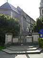 All Saints Church Parishioners war memorial.


References
- ^ All Saints' Friern Barnet. Retrieved 31 May 2016.
- ^ a b c CHURCH OF ALL SAINTS. Historic England. Retrieved 31 May 2016.
- ^ Heathfield, John & David Berguer. (2016) Whetstone Revealed. London: Chaville Press. p. 165. ISBN 9780993006333
- ^ http://www.iwm.org.uk/memorials/item/memorial/48206
External links
 Media related to All Saints Church at Wikimedia Commons
- Media related to All Saints Church Parishioners war memorial at Wikimedia Commons
51°37′45″N 0°09′59″W / 51.6292°N 0.1664°W