Ane, Overijssel
Appearance
Ane
Aone | |
|---|---|
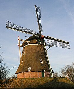
 The Anermolen (windmill of Ane | |
Location in province of Overijssel in the Netherlands | |
| Coordinates: 52°36′48″N 6°39′3″E / 52.61333°N 6.65083°E | |
| Country | Netherlands |
| Province | Overijssel |
| Municipality | Hardenberg |
| Area | |
• Total | 8.54 km2 (3.30 sq mi) |
| Elevation | 10 m (30 ft) |
| Population (2021)[1] | |
• Total | 560 |
| • Density | 66/km2 (170/sq mi) |
| Time zone | UTC+1 (CET) |
| • Summer (DST) | UTC+2 (CEST) |
| Postal code | 7784[1] |
| Dialing code | 0524 |
Ane (Dutch Low Saxon: Aone) is a village in the Dutch province of Overijssel. It is located in the municipality Hardenberg, about 5 km northeast of the centre of Hardenberg.
In 1227, the Battle of Ane was fought during which the bishop of Utrecht was defeated by the citizens of Drenthe.[3] In 1840, it was home to 358 people.[4] In 1864, the gristmill Anermolen was built. It was restored in 1981.[5]
References
[edit]- ^ a b c "Kerncijfers wijken en buurten 2021". Central Bureau of Statistics. Retrieved 14 March 2022.
- ^ "Postcodetool for 7784CB". Actueel Hoogtebestand Nederland (in Dutch). Het Waterschapshuis. Retrieved 14 March 2022.
- ^ Jan ten Hove (1998). "Gramsbergen" (in Dutch). Zwolle: Waanders. p. 154. ISBN 90 400 9200 1. Retrieved 14 March 2022.
- ^ "Ane". Plaatsengids (in Dutch). Retrieved 14 March 2022.
- ^ "Anermolen". Molendatabase (in Dutch). Retrieved 14 March 2022.
Wikimedia Commons has media related to Ane.


