
Arcen
Arcen | |
|---|---|
Dorp | |
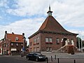
 Arcen: Gemeentehuis | |
| Coordinates: 51°24′42″N 6°10′4″E / 51.41167°N 6.16778°E | |
| Country | Netherlands |
| Province | Limburg |
| Municipality | Venlo |
| Area | |
| • Total | 11.47 km2 (4.43 sq mi) |
| Population (2007) | 2,230 |
| Dialling code | 077 |
This article contains content that is written like an advertisement. (May 2011) |
Arcen (Limburgish: Ârce) is a village in the Dutch province of Limburg. In 2010, it became part of the municipality of Venlo. Previously, it had been part of the municipality of Arcen en Velden and the seat of 'het gemeentehuis' (Town Hall).
In 2001, Arcen had 1884 inhabitants. The built-up area of the town was 0.39 km2, and contained 747 residences.[1]
Its location on the river Maas makes it a popular tourist attraction. It is wedged in between Germany in the east and the river Maas in the west. National Park de Hamert lies just north of Arcen. Historic buildings include the 'Schanstoren' (Schans Tower) and the castle as well as century old houses in the village itself. The town hall is of a Traditionalist 20th century design by A.J. Kropholler while the church was designed in a similar style by H.W. Valk. Outside the centre are the Hertog Jan beer brewery and the 'De IJsvogel' distillery, which is located in a historic water mill and produces jenever (gin) and bitters and liquors.
Near Arcen lies the only preserved fortress built to protect the Fossa Eugeniana, a canal built between 1625 and 1629 to connect the rivers Rhine and Maas.
Arcen has a thermal bath and various holiday parks.
Arcen's 'Kasteeltuinen' (castle gardens) went bankrupt in 2012.
Arcen is the birthplace of former Dutch soccer international Stan Valckx.
Gallery
-
 Arcen, former town hall
 -
 Arcen, church


References
- ^ Statistics Netherlands (CBS), Bevolkingskernen in Nederland 2001 "Archived copy". Archived from the original on 2006-03-19. Retrieved 2007-01-24.
{{cite web}}: Unknown parameter|deadurl=ignored (|url-status=suggested) (help)CS1 maint: archived copy as title (link). Statistics are for the continuous built-up area.
External links
 Media related to Arcen at Wikimedia Commons
 Arcen travel guide from Wikivoyage
- Castle Gardens
51°28′35″N 6°10′51″E / 51.4765°N 6.1808°E
This Dutch Limburg location article is a stub. You can help Wikipedia by expanding it. |