Arda Peak
Appearance


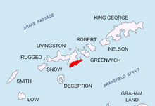
Arda Peak (Vrah Arda \'vr&h 'ar-da\) is located in the east of Livingston Island, Antarctica. The peak rises to approximately 470 m and is located in the Friesland Ridge, Tangra Mountains, overlooking the lower course of Charity Glacier to the northwest and Tarnovo Ice Piedmont to the southeast. The peak is named after the river Arda in Bulgaria.
Location
Arda Peak is located at 62°44′27.2″S 60°17′32″W / 62.740889°S 60.29222°W which is 430 m south of Gabrovo Knoll, 890 m east by north of the summit of Veleka Ridge and 2.85 km west of Yambol Peak.
Maps
- L.L. Ivanov et al. Antarctica: Livingston Island and Greenwich Island, South Shetland Islands. Scale 1:100000 topographic map. Sofia: Antarctic Place-names Commission of Bulgaria, 2005.
- L.L. Ivanov. Antarctica: Livingston Island and Greenwich, Robert, Snow and Smith Islands. Scale 1:120000 topographic map. Troyan: Manfred Wörner Foundation, 2009.
References
- Arda Peak. SCAR Composite Gazetteer of Antarctica.
- Bulgarian Antarctic Gazetteer. Antarctic Place-names Commission. (details in Bulgarian, basic data in English)
This article includes information from the Antarctic Place-names Commission of Bulgaria which is used with permission.
