
Armel, Virginia
Armel | |
|---|---|
 Armel Location within the Commonwealth of Virginia  Armel Armel (the United States) | |
| Coordinates: 39°4′45″N 78°8′37″W / 39.07917°N 78.14361°W | |
| Country | United States |
| State | Virginia |
| County | Frederick |
| Time zone | UTC−5 (Eastern (EST)) |
| • Summer (DST) | UTC−4 (EDT) |
| GNIS feature ID | 1499061[1] |
Armel is an unincorporated community in Frederick County, Virginia, United States. It lies east of Stephens City on Front Royal Pike (U.S. Highway 522). According to the Geographic Names Information System, Armel has also been known throughout its history as Bridgeport.
References
Municipalities and communities of Frederick County, Virginia, United States | ||
|---|---|---|
| Towns | 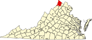 | |
| CDPs | ||
| Other communities |
| |
This Frederick County, Virginia state location article is a stub. You can help Wikipedia by expanding it. |