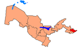
Asaka District
Appearance
Asaka | |
|---|---|
| Asaka tumani | |
 | |
| Country | Uzbekistan |
| Region | Andijan Region |
| Capital | Asaka |
| Established | 1926 |
| Area | |
• Total | 270 km2 (100 sq mi) |
| Population (2022) | |
• Total | 340,000 |
| • Density | 1,300/km2 (3,300/sq mi) |
| Time zone | UTC+5 (UZT) |
Asaka is a district of Andijan Region in Uzbekistan. The capital lies at Asaka.[1] It has an area of 270 km2 (100 sq mi)[2] and it had 340,000 inhabitants in 2022.[3]
The district consists of 1 city (Asaka), 4 urban-type settlements (Kujgan, Navkan, Oqboʻyra and T.Aliyev) and 8 rural communities.[1]
Asaka has always been eminent for its transportation means,- for its horses in the past and cars that GM Uzbekistan (car-manufacturing plant located in the heart of the district) produces today. In fact, the town is named after a beautiful horse which, according to a folk legend, was owned by a local mustanger.
References
[edit]- ^ a b "Classification system of territorial units of the Republic of Uzbekistan" (in Uzbek and Russian). The State Committee of the Republic of Uzbekistan on statistics. July 2020.
- ^ "O'zbekiston Respublikasining ma'muriy-hududiy bo'linishi" [Administrative-territorial division of the Republic of Uzbekistan] (PDF) (in Uzbek). Andijan regional department of statistics.
- ^ "Hududlar bo'yicha shahar va qishloq aholisi soni" [Urban and rural population by district] (PDF) (in Uzbek). Andijan regional department of statistics.

