Ashland station (MBTA)
ASHLAND | ||||||||||||||||||||||||||||||
|---|---|---|---|---|---|---|---|---|---|---|---|---|---|---|---|---|---|---|---|---|---|---|---|---|---|---|---|---|---|---|
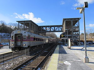
 An inbound train arrives at Ashland station | ||||||||||||||||||||||||||||||
| General information | ||||||||||||||||||||||||||||||
| Location | Pleasant Street near High Street Ashland, Massachusetts | |||||||||||||||||||||||||||||
| Coordinates | 42°15′42″N 71°28′57″W / 42.2616°N 71.4826°W | |||||||||||||||||||||||||||||
| Line(s) | ||||||||||||||||||||||||||||||
| Platforms | 2 side platforms | |||||||||||||||||||||||||||||
| Tracks | 2 | |||||||||||||||||||||||||||||
| Construction | ||||||||||||||||||||||||||||||
| Parking | 678 spaces ($4.00 fee) 16 accessible spaces | |||||||||||||||||||||||||||||
| Accessible | Yes | |||||||||||||||||||||||||||||
| Other information | ||||||||||||||||||||||||||||||
| Fare zone | 6 | |||||||||||||||||||||||||||||
| History | ||||||||||||||||||||||||||||||
| Opened | August 24, 2002[1] | |||||||||||||||||||||||||||||
| Passengers | ||||||||||||||||||||||||||||||
| 2013 | 691 (weekday inbound average)[2] | |||||||||||||||||||||||||||||
| Services | ||||||||||||||||||||||||||||||
| ||||||||||||||||||||||||||||||
Ashland is a regional rail station on the MBTA Commuter Rail Framingham/Worcester Line, located on Pleasant Street in Ashland, Massachusetts. It also has a long driveway leading from the south parking lot to the intersection of West Union Street (MA 135) and Voyagers Lane. Like the other stations on the line west of Framingham, Ashland serves as a park-and-ride station with 678 parking spots.
History

Passenger service to the old Shepley, Rutan and Coolidge-built downtown station ended on April 24, 1960, when Boston and Albany Railroad service west of Framingham was cut to stops at Worcester, Palmer, Springfield, and Pittsfield only.[3] Service to Worcester ended entirely in 1975, but resumed in 1994.[1]
In the late 1990s, due to delays in the restoration of passenger service on the Old Colony Lines and the Greenbush Line, four park-and-ride stations were built between Framingham and Worcester. Ashland was the last on these to open, on August 22, 2002.[1] The new station was built to the west of the town center, where land was available for large parking lots. The downtown station still stands, and is currently used as a doctor's office.[4]
References
- ^ a b c Belcher, Jonathan (24 May 2013). "Changes to Transit Service in the MBTA district" (PDF). NETransit. Retrieved 26 May 2013.
- ^ "Ridership and Service Statistics" (PDF) (14 ed.). Massachusetts Bay Transportation Authority. 2014. Retrieved 7 January 2016.
- ^ Humphrey, Thomas J.; Clark, Norton D. (1985). Boston's Commuter Rail: The First 150 Years. Boston Street Railway Association. p. 24. ISBN 9780685412947.
{{cite book}}: Unknown parameter|lastauthoramp=ignored (|name-list-style=suggested) (help) - ^ Roy, John H. Jr. (2007). A Field Guide to Southern New England Railroad Depots and Freight Houses. Branch Line Press. p. 125. ISBN 9780942147087.
External links
![]() Media related to Ashland (MBTA station) at Wikimedia Commons
Media related to Ashland (MBTA station) at Wikimedia Commons
