
Askeran Fortress
| Askeran fortress | |
|---|---|
Azerbaijani: Əsgəran qalası | |
| Askeran, Azerbaijan | |
.jpg) The remains of the fortress. | |
| Coordinates | 39°56′00″N 46°49′53″E / 39.9333°N 46.8314°E |
| Type | Fortress |
| Site history | |
| Built | 1751[1] |
| Materials | Cobblestone |
Askeran fortress (Azerbaijani: Əsgəran qalası, also called Mayraberd in Armenian), is a fortress in the town of Askeran in Azerbaijan (de jure), in the Armenian-controlled Republic of Artsakh (de facto). It is on the banks of the Qarqar River and was built by the Karabakh khanate ruler Panah Ali Khan[2][3] and consists of two sections. The left-bank section features a double line of stone walls.
During the Russo-Persian War of 1804–1813 the Russian encampment was near the fortress. In 1810 the peace talks between the Russians and Persians were conducted at the fortress.[2]
Gallery
-
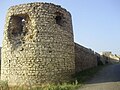 A view of one of the towers of the fortress.
 -
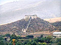 General view

.jpg)
Notes
- ^ Carney, James. "Former Soviet Union: Carnage in Karabakh." TIME Magazine. April 13, 1992.
- ^ a b Azerbaijan Soviet Encyclopedia (1980), vol. 4, p. 233.
- ^ John Noble, Michael Kohn, Danielle Systermans. Georgia, Armenia and Azerbaijan, Lonely Planet, 2008, p. 306