
Aurelle, Arkansas
Aurelle, Arkansas | |
|---|---|
| Country | United States |
| State | Arkansas |
| County | Union |
| Elevation | 217 ft (66 m) |
| Time zone | UTC-6 (Central (CST)) |
| • Summer (DST) | UTC-5 (CDT) |
| Area code | 870 |
| GNIS feature ID | 57293[1] |
Aurelle is an unincorporated community in Union County, Arkansas, United States. Aurelle is located at the end of a paved road 5 miles (8.0 km) south-southwest of Strong.[2]
References
Municipalities and communities of Union County, Arkansas, United States | ||
|---|---|---|
| Cities | 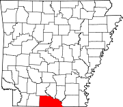 | |
| Town | ||
| CDPs | ||
| Other unincorporated communities | ||
This Arkansas state location article is a stub. You can help Wikipedia by expanding it. |