Avers (Kreis)
Appearance
Kreis Avers
Kreis Avers | |
|---|---|
Sub-district | |
 | |
| Country | |
| Canton | |
| Capital | Avers |
| Area | |
• Total | 93.12 km2 (35.95 sq mi) |
| Population (2009) | |
• Total | 164 |
| • Density | 1.8/km2 (4.6/sq mi) |
| Time zone | UTC+1 (CET) |
| • Summer (DST) | UTC+2 (CEST) |
| Municipalities | 1 |
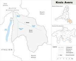
The Kreis Avers forms, together with the Kreise of Domleschg, Rheinwald, Schams and Thusis the [Bezirk] Error: {{Lang}}: text has italic markup (help) ("district") of Hinterrhein of the Canton of Graubünden in Switzerland. The seat of the sub-district office is in Avers.
Municipalities
The Kreis ("sub-district") contains only one municipality:
46°28′N 9°30′E / 46.467°N 9.500°E
