
Bödefeld
Bödefeld | |
|---|---|
.jpg) | |
 Coat of arms | |
Location of Bödefeld  | |
 Bödefeld  Bödefeld | |
| Coordinates: 51°14′51″N 8°23′33″E / 51.24750°N 8.39250°E | |
| Country | Germany |
| State | North Rhine-Westphalia |
| Admin. region | Arnsberg |
| District | Hochsauerlandkreis |
| Town | Schmallenberg |
| Population (2021-12-31) | |
| • Total | 1,102 |
| Time zone | UTC+01:00 (CET) |
| • Summer (DST) | UTC+02:00 (CEST) |
Bödefeld is a village in the municipality Schmallenberg in the High Sauerland District in North Rhine-Westphalia, Germany.
The village has 1102 inhabitants[1] and lies northeastern of the municipality of Schmallenberg at a height of around 488 m. The river Palme flows through the village. Bödefeld borders on the villages of Gellinghausen, Westernbödefeld, Brabecke, Osterwald, Obervalme (Bestwig), Lanfert, Hiege and Walbecke.
The village used to belong to the municipality of Freiheit Bödefeld in Amt Fredeburg until the end of 1974.[2]
Gallery[edit]
-
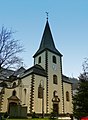 Saints Cosmas and Damian Church
 -
 Bödefeld, 1905


External links[edit]
References[edit]
- ^ Schmallenberg.de: Inhabitants Archived 2023-03-23 at the Wayback Machine (in German)
- ^ Statistisches Bundesamt (Hrsg.): Historisches Gemeindeverzeichnis für die Bundesrepublik Deutschland. Namens-, Grenz- und Schlüsselnummernänderungen bei Gemeinden, Kreisen und Regierungsbezirken vom 27.5.1970 bis 31.12.1982. W. Kohlhammer, Stuttgart/Mainz 1983, ISBN 3-17-003263-1, S. 335 f.
| Authority control databases: National |
|---|