Bad Rothenfelde
Appearance
Bad Rothenfelde | |
|---|---|
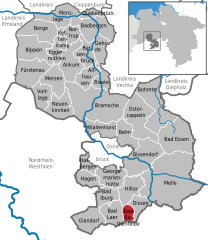
Location of Bad Rothenfelde within Osnabrück district  | |
| Country | Germany |
| State | Lower Saxony |
| District | Osnabrück |
| Government | |
| • Mayor | Klaus Rehkämper (CDU) |
| Area | |
• Total | 18.19 km2 (7.02 sq mi) |
| Elevation | 96 m (315 ft) |
| Population (2022-12-31)[1] | |
• Total | 8,597 |
| • Density | 470/km2 (1,200/sq mi) |
| Time zone | UTC+01:00 (CET) |
| • Summer (DST) | UTC+02:00 (CEST) |
| Postal codes | 49214 |
| Dialling codes | 05424 |
| Vehicle registration | OS |
| Website | www.bad-rothenfelde.de |
Bad Rothenfelde is a municipality and health resort in the district of Osnabrück, in Lower Saxony, Germany. It is situated in the Teutoburg Forest, approx. 20 km southeast of Osnabrück, between Hilter and Dissen. Bad Rothenfelde has a spa, hospitals, clothes shops and many cafés.
References


