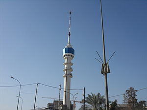
Baghdad Tower
Appearance
| Baghdad Tower | |
|---|---|
Ma'moon Tower | |
 | |
 | |
| Former names | International Saddam Tower |
| General information | |
| Status | constructed |
| Type | Mixed use: telecommunication, restaurant, observation |
| Location | Baghdad, Iraq |
| Completed | 1994 |
| Renovated | 2010 |
| Destroyed | 1991, 2003 |
| Height | |
| Antenna spire | 205.0 m (673 ft) |
Baghdad Tower (Template:Lang-ar) (previously called International Saddam Tower) is a 205 m (673 ft) TV tower in Baghdad, Iraq. The tower opened in 1994 and replaced a communications tower destroyed in the Gulf War. A revolving restaurant and observation deck are located on the top floor. After the 2003 invasion of Iraq, the tower was occupied by American soldiers and was renamed.
Gallery
-
The Baghdad Tower, on the right.
-
Baghdad Tower, July 2007.
-
Rebuilding the tower and its surroundings.
-
Tower Center, December 2010
-
Tower Center, December 2010
External links
- Baghdad Tower on Skyscraperpage.com
- Baghdad Television Tower at Structurae
- Information to the reconstruction
33°18′12″N 44°21′15″E / 33.30333°N 44.35417°E


