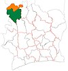
Bako, Ivory Coast
Appearance
Bako | |
|---|---|
Town, sub-prefecture, and commune | |
| Coordinates: 9°8′N 7°37′W / 9.133°N 7.617°W | |
| Country | |
| District | Denguélé |
| Region | Kabadougou |
| Department | Odienné |
| Population (2014)[1] | |
| • Total | 17,253 |
| Time zone | UTC+0 (GMT) |
Bako is a town in north-western Ivory Coast. It is a sub-prefecture and commune of Odienné Department in Kabadougou Region, Denguélé District.
In the Dioula language of Ivory Coast and the Bambara language of Mali, "Bako" means "behind the river": "Ba" means "river" and "ko" means "behind". The people of the town are mostly agrarian.
References
- ^ "Côte d'Ivoire". geohive.com. Retrieved 8 December 2015.


