Ballon d'Alsace
Appearance
| Ballon d'Alsace | |
|---|---|
 | |
| Highest point | |
| Elevation | 1,247 m (4,091 ft) |
| Prominence | 211 m (692 ft)[citation needed] |
| Geography | |
Lua error in Module:Location_map at line 526: Unable to find the specified location map definition: "Module:Location map/data/France relief" does not exist.
| |
| Region | FR |
| Parent range | Vosges |
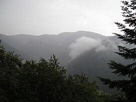
Ballon d'Alsace German: Elsässer Belchen (el. 1247 m.) is a mountain at the border of Alsace, Lorraine, and Franche-Comté. From its top, views include the Vosges, the Rhine valley, and the Black Forest.
A road leads over a pass near the peak at 1,171 m (3,842 ft).
Ballon d'Alsace is noted as the site of the first official mountain climb in the Tour de France on 10 July 1905, won by René Pottier. Stage 9 of the 2005 Tour crossed this pass on the centenary of the original climb.
