Bandrélé
Bandrele | |
|---|---|
 Mtsamoudou village, Bandrélé commune | |
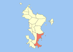
 Location of the commune (in red) within Mayotte | |
| Country | France |
| Government | |
| • Mayor | Moussa Madi |
| Area 1 | 36.46 km2 (14.08 sq mi) |
| Population (2012 census) | 7,885 |
| • Density | 220/km2 (560/sq mi) |
| Time zone | UTC+01:00 (CET) |
| • Summer (DST) | UTC+02:00 (CEST) |
| INSEE/Postal code | 98503 /97660 |
| Elevation | 0–297 m (0–974 ft) |
| 1 French Land Register data, which excludes lakes, ponds, glaciers > 1 km2 (0.386 sq mi or 247 acres) and river estuaries. | |
Bandrele (sometimes spelled Bandrélé) is a commune in the French overseas department of Mayotte, in the Indian Ocean.
Villages

Wikimedia Commons has media related to Bandrélé.

