
Banoak, North Carolina
Banoak, North Carolina | |
|---|---|
 Banoak  Banoak | |
| Coordinates: 35°35′10″N 81°24′32″W / 35.58611°N 81.40889°W | |
| Country | United States |
| State | North Carolina |
| County | Catawba |
| Elevation | 1,175 ft (358 m) |
| Time zone | UTC-5 (Eastern (EST)) |
| • Summer (DST) | UTC-4 (EDT) |
| Area code | 828 |
| GNIS feature ID | 980533[1] |
Banoak (also known as Corinth)[1][2] is an unincorporated community in Catawba County, North Carolina, United States. Banoak is located on North Carolina Highway 10, 10.8 miles (17.4 km) south-southwest of Hickory.[2]
References
- ^ a b "Banoak". Geographic Names Information System. United States Geological Survey, United States Department of the Interior.
- ^ a b Catawba County, North Carolina (Map). North Carolina Department of Transportation. 2010. p. 1.
Municipalities and communities of Catawba County, North Carolina, United States | ||
|---|---|---|
| Cities | 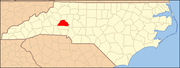 | |
| Towns | ||
| CDPs | ||
| Unincorporated communities | ||
| Footnotes | ‡This populated place also has portions in an adjacent county or counties | |