
Barmouth station (SEPTA)
| Former SEPTA regional rail station | |||||||||||||||||||||
| File:Barmouth July 7, 1985.jpg Barmouth SEPTA station, July 1985. Passenger trains operated as far as Ivy Ridge at the time. | |||||||||||||||||||||
| General information | |||||||||||||||||||||
| Location | East Levering Mill Road Lower Merion, Pennsylvania | ||||||||||||||||||||
| Coordinates | 40°00′58″N 75°13′39″W / 40.0161°N 75.2274°W | ||||||||||||||||||||
| Platforms | 2 (demolished) | ||||||||||||||||||||
| Tracks | 2 | ||||||||||||||||||||
| Construction | |||||||||||||||||||||
| Structure type | shelters (demolished) | ||||||||||||||||||||
| Accessible | No | ||||||||||||||||||||
| History | |||||||||||||||||||||
| Closed | 1986 | ||||||||||||||||||||
| Electrified | yes | ||||||||||||||||||||
| Former services | |||||||||||||||||||||
| |||||||||||||||||||||
Barmouth station was a railroad station in Lower Merion, Pennsylvania. Located on East Levering Mill Road, the station was a stop on the Pennsylvania Railroad's Schuylkill Branch, and later became a part of SEPTA's Ivy Ridge Line (then called R6 Ivy Ridge).
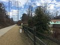
The station, and all of those north of Cynwyd station, was closed in September 1986 when the integrity of the Pencoyd Viaduct crossing the Schuylkill River and Schuylkill Expressway was questioned. In 2009, SEPTA leased the line to Lower Merion Township, who dismantled the tracks for the Cynwyd Heritage Trail.[1][2] The last remnants of the station, the platforms and a stone shelter, were demolished in 2011 to make room for the trail parking lot.[3][4]
The Barmouth station site bisects West Laurel Hill Cemetery and Westminster Cemetery.
Gallery
-
 Former Pennsylvania Railroad station site
 -
 Entrance to cemetery at the Barmouth trailhead
 -
 Trail at mile marker 5
 -
 Trail is located where tracks were once located
 -
 Trail markers showing Cynwyd station and the Barmouth trailhead


References
External links
This Pennsylvania train station-related article is a stub. You can help Wikipedia by expanding it. |
This article related to SEPTA is a stub. You can help Wikipedia by expanding it. |
- Railway stations closed in 1986
- Former SEPTA Regional Rail stations
- Former Pennsylvania Railroad stations
- Defunct railway stations in the United States
- Lower Merion Township, Montgomery County, Pennsylvania
- Railway stations in Montgomery County, Pennsylvania
- 1986 disestablishments in Pennsylvania
- Pennsylvania railway station stubs
- SEPTA stubs