Barrow Island, Barrow-in-Furness
| Barrow Island | |
|---|---|
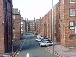
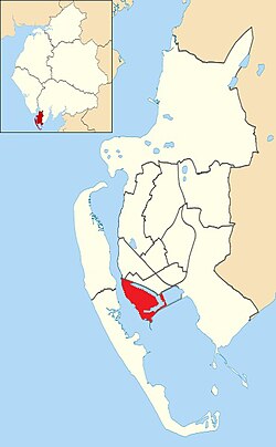
 Tenements on Steamer Street, Barrow Island Tenements on Steamer Street, Barrow Island Barrow Island shown within Barrow-in-Furness | |
| Population | 2,616 |
| District | |
| Shire county | |
| Region | |
| Country | England |
| Sovereign state | United Kingdom |
| Post town | BARROW-IN-FURNESS |
| Postcode district | LA |
| Dialling code | 01229 |
| Police | Cumbria |
| Fire | Cumbria |
| Ambulance | North West |
| UK Parliament | |
Barrow Island is an area and electoral ward of Barrow-in-Furness, England. Originally separate from the British mainland, land reclamation in the 1860s saw the northern fringes of the island connect to Central Barrow. Barrow Island is also bound to the south and east by the town's dock system and to the west by Walney Channel.
Background and History

The name of the town of Barrow-in-Furness is believed to derive from the Norse word Barrae, meaning Bare Island, which actually referred to Barrow Island. Since the 1860s the island has been connected to the mainland as its channel was modified to form two docks, the Buccleuch Dock and the Devonshire Dock. The remainder of its channel has also now been developed as part of the dock system. The Island is also known as 'Old Barrow'.
The World War Two defences constructed around Barrow Island have been documented by William Foot. They included a number of pillboxes to defend the docks. The principal threat was seizure of the docks by airborne troops;[1] a seaborne landing was thought to be highly unlikely unless Ireland was occupied first.
Still classed as one of the Islands of Furness, Barrow Island is characterised by densely constructed tenement housing alongside huge industrial buildings. The area is home to the vast majority of Barrow's shipyard including the Devonshire Dock Hall complex - the main occupier of the reclaimed land from Walney Channel. In 2011, the wards population stood at 2,616 which although relatively small compared to Barrow's other wards equates to a higher population density, and twice that of national average.
Shipyard

The island is home to Barrow Shipyard, owned now by BAE Systems. Former owners include The Barrow Iron Ship-Building Company, Vickers Shipbuilding, VSEL and Marconi Marine (VSEL), which became part of BAE in 1999. The shipyard remains one of the largest in the United Kingdom, rivalled only by that of Govan. The island also forms a major part of the Port of Barrow, owned by Associated British Ports. A large portion of The Waterfront Barrow-in-Furness is planned to be constructed on Barrow Island.
The urbanisation of Barrow Island came about entirely as a result of the booming shipyard. Today many of the existing shipyard buildings were constructed by VSEL, including the huge Heavy Engineering Workshop and Devonshire Dock Hall complex. Despite this, current owners BAE Systems have ambitious expansion plans on Barrow Island associated with the Trident successor programme.
Barrow Island itself is a Conservation Area, while many of the shipyard buildings are listed buildings - as are numerous tenement houses including the Grade II* listed Devonshire Buildings.
Demographics


According to the 2011 census, males outnumbered females in Barrow Island to significant degree which is in contrast to the Barrow and national averages.[2] Deprivation is measured in Barrow Island by its high percentage of individuals with long term illnesses and an unemployment rate almost twice as high as England's average.[2]
| Vital statistics.[2] | Barrow Island | Barrow-in-Furness | England |
|---|---|---|---|
| Males | 53.2% | 49.5% | 49.2% |
| Females | 46.8% | 50.5% | 50.8% |
| Individuals in fairly good to good health |
70.7% | 75.9% | 81.4% |
| Individuals in bad health | 29.3% | 24.1% | 18.6% |
| People aged 16–74 who are economically active |
61.0% | 64.0% | 66.5% |
| People aged 16–74 who aren't economically active |
39.0% | 36.0% | 33.5% |
| People aged 16–74 with no qualifications |
28.2% | 25.4% | 22.5% |
Transport
The A590 trunk road runs across the northern edge of Barrow Island before crossing Walney Bridge and terminating on Walney Island. To the south of Barrow Island, Michaelson Road Bridge is another vehicle and foot bridge that crosses Buccleuch Dock into Central Barrow. Island Road is a wide tree-lined boulevard that acts as the primary artery through Barrow Island's eastern residential areas.
Tramlines of the former Barrow-in-Furness Tramways Company are preserved across much of Barrow Island.
See also
References
- ^ Foot, 2006, p105.
- ^ a b c "Barrow Island: Key Figures for 2011 Census". Office for National Statistics. Retrieved 19 August 2014.
- Foot, William (2006). Beaches, fields, streets, and hills ... the anti-invasion landscapes of England, 1940. Council for British Archaeology. ISBN 1-902771-53-2.
- Map sources for Barrow Island, Barrow-in-Furness
