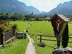
Bayerisch Gmain
Appearance
Bayerisch Gmain | |
|---|---|
 | |
Location of Bayerisch Gmain within Berchtesgadener Land district  | |
| Coordinates: 47°43′N 12°54′E / 47.717°N 12.900°E | |
| Country | Germany |
| State | Bavaria |
| Admin. region | Oberbayern |
| District | Berchtesgadener Land |
| Government | |
| • Mayor (2019–25) | Armin Wierer[1] (FW) |
| Area | |
| • Total | 11.40 km2 (4.40 sq mi) |
| Elevation | 540 m (1,770 ft) |
| Population (2023-12-31)[2] | |
| • Total | 3,202 |
| • Density | 280/km2 (730/sq mi) |
| Time zone | UTC+01:00 (CET) |
| • Summer (DST) | UTC+02:00 (CEST) |
| Postal codes | 83457 |
| Dialling codes | 08651 |
| Vehicle registration | BGL |
| Website | www.bayerisch-gmain.de |
Bayerisch Gmain is a municipality and a village in the district of Berchtesgadener Land in Bavaria in Germany.
Notable residents
[edit]- Hans Erlwein (1872–1914), architect, town councilor in Bamberg and Dresden
- Claire Waldoff (1884–1957), cabaret artist, singer, lived from 1939 until her death in Bayerisch Gmain
- Ines Papert (born 1974), German sport climber and ice climbing champion
- Johannes Frießner (1892-1971) German Commander of XXIII Army Corps during World War Two
References
[edit]- ^ Liste der ersten Bürgermeister/Oberbürgermeister in kreisangehörigen Gemeinden, Bayerisches Landesamt für Statistik, accessed 19 July 2021.
- ^ Genesis Online-Datenbank des Bayerischen Landesamtes für Statistik Tabelle 12411-003r Fortschreibung des Bevölkerungsstandes: Gemeinden, Stichtag (Einwohnerzahlen auf Grundlage des Zensus 2011).


