
Beaverton, Montana
This article relies largely or entirely on a single source. (January 2015) |
Beaverton is an unincorporated community in Valley County, Montana, United States located near Beaver Creek on the Valley County/Phillips County line.[1] The community itself is all but a ghost town, with First Creek Seeds being the only remaining feature. Beaverton is halfway between the town of Saco and the community of Hinsdale.
| Year | Population |
|---|---|
| 1920 | 149[2] |
| 1930 | 129[2][3] |
| 1940 | 87[3] |
| 1950 | 86[3] |
1950 is the last year Beaverton was included as its own district in the U.S. Census.

References
- ^ "Beaverton, Montana". Geographic Names Information System. United States Geological Survey, United States Department of the Interior. Retrieved January 6, 2015.
- ^ a b Bureau of the Census, United States of America (1931). Fifteenth census of the United States: 1930. Population, Volume 1, Number and Distribution of Inhabitants. Washington, D.C.: United States Government Printing Office. p. 657. Retrieved 13 May 2016.
- ^ a b c Bureau of the Census, United States of America (1952). A Report of the Seventeenth Decennial Census of the United States: Census Population 1950: Volume I, Number of Inhabitants. Washington, D.C.: United States Government Printing Office. p. 26-15. Retrieved 13 May 2016.
Municipalities and communities of Valley County, Montana, United States | ||
|---|---|---|
| City | 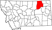 | |
| Towns | ||
| CDPs | ||
| Other communities | ||
| Indian reservations | ||
| Ghost towns | ||
| Footnotes | ‡This populated place also has portions in an adjacent county or counties | |
48°25′25″N 107°15′14″W / 48.42361°N 107.25389°W
This Montana state location article is a stub. You can help Wikipedia by expanding it. |