
Begowala
This article needs additional citations for verification. (June 2009) |
Begowala
بیگووالہ | |
|---|---|
 Begowala | |
| Coordinates: 32°16′N 74°10′E / 32.26°N 74.16°E | |
| Country | |
| Province | Punjab |
| Government | |
| • Chairman | Imran cheema |
| Population (1998) | |
| • Total | 20 Thousands |
| • Estimate (2018) | 35 Thousands |
| Time zone | UTC+5 (PST) |
| Calling code | 0526204 |
| Website | www |
Begowala (Urdu: بیگووالہ) is a town of District Sialkot in the Punjab province of Pakistan. It is located in the centre of the Sialkot-Sambrial road and lies 10 km away from Sambrial. Begowala is one of the biggest villages of Sialkot among 161 villages.
Brief history
Begowala still has Temples where Hindus and Sikhs used to worship their gods and now these temples are preserved as the property of Government.[citation needed] Some Sikhs often visit Begowala to remind them of their past. The Managing Director of Usha Fabs, Delhi and Vice-Chairman of Apparel Export Promotion Council, Mr. Rakesh Vaid, said "Our family lived in Begowala for over 175 years." CH. Azmat Ullah Cheema (Shaheed) is well known famous personality and Ex. Nazim of Begowala.
Geography and climate
Begowala is cold during winters and hot and humid during summers. May and June are the hottest months. The temperature during winter may drop to 0°C. The land is, generally, plain and fertile. Most of the rain falls during the Monsoon season in summer which often results in flooding. Begowala has one of the most modern weather forecasting and flood warning centres in the country, which is fully equipped to record and transfer data to and from the relevant concerns. This facility is equipped with a radar and is internationally linked.
Images
-
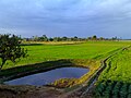 Field
Field -
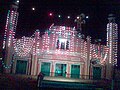 Jamia Mosque
 -
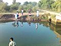 Ayek Naala


