Bekkestua station
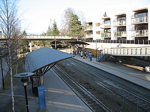
 Bekkestua Metro station before the reopening. | |||||||||||||||||||||
| General information | |||||||||||||||||||||
| Location | Bekkestua, Bærum Norway | ||||||||||||||||||||
| Coordinates | 59°54′59″N 10°35′15″E / 59.91633°N 10.58756°E | ||||||||||||||||||||
| Elevation | 58.9 m | ||||||||||||||||||||
| Owned by | Sporveien | ||||||||||||||||||||
| Operated by | Sporveien T-banen | ||||||||||||||||||||
| Line(s) | Kolsås Line | ||||||||||||||||||||
| Distance | 11.4 km from Stortinget | ||||||||||||||||||||
| Tracks | 3 | ||||||||||||||||||||
| Connections | Bus: 131, 143, 731, 732, 733, 771, 772, 773 and F3 | ||||||||||||||||||||
| Construction | |||||||||||||||||||||
| Structure type | At-grade | ||||||||||||||||||||
| Parking | None | ||||||||||||||||||||
| Bicycle facilities | Yes | ||||||||||||||||||||
| Accessible | Yes | ||||||||||||||||||||
| Other information | |||||||||||||||||||||
| Fare zone | 1 | ||||||||||||||||||||
| History | |||||||||||||||||||||
| Opened | 1 May 1924 | ||||||||||||||||||||
| Rebuilt | 1 June 2006 - 15 August 2011 | ||||||||||||||||||||
| Services | |||||||||||||||||||||
| |||||||||||||||||||||
Bekkestua is a station on Kolsås Line of the Oslo Metro situated at Bekkestua in Bærum, Norway.
Located between Egne Hjem and Gjønnes, it was reopened on 15 August 2011 after being closed on 1 July 2006. Between 1 July 2003 and November 2004, Bekkestua was the end station on the Kolsås Line.[1] For a while the station was only being served by the Oslo Tramway line 13, while the station was closed for an upgrade.
Since 2 December 2007 tram operations (line 13) have returned on this line from Jar to Bekkestua. Operations beyond Jar use SL95 trams as there is no turnback loop at Bekkestua. The tram operations were discontinued in 2009, but reopened in January 2014 after technical difficulties delayed the opening by one month.
References
External links
![]() Media related to Bekkestua stasjon at Wikimedia Commons
Media related to Bekkestua stasjon at Wikimedia Commons
59°54′59″N 10°35′15″E / 59.91633°N 10.58756°E

