
Biel Water

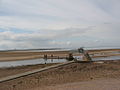
The Biel Water is a river running through the Biel Estate in Biel, East Lothian. It runs for 4.5 kilometres from the Luggate Burn and the Whittinghame Water, via Stenton, Biel House, West Barns, and finally to Belhaven Bay with its rather unusual bridge, whose ends are submerged at high tide.[1][2]
See also[edit]
References[edit]
- ^ "The Submerged Bridge over Biel Water in Belhaven Bay".
- ^ The floods of 12 August 1948, in South-East Scotland, Author: A. T. A. Learmonth, publ. in Scottish Geographical Journal, Volume 66, Issue 3 and 4 December 1950, pages 147 - 153
External links[edit]
Photo gallery[edit]
-
 New crossing at Biel Water, flood relief
 -
 The Bridge at Biel Water, Belhaven
 -
 The bridge at high tide


.jpg)