
Bog River
The Bog River, also called the Bog River Flow is a 18-mile (29 km) river that originates near the sources of the Oswegatchie River, in Hamilton County, New York in the Adirondacks, and flows through Lows Lake and Hitchens Pond, ending at the Bog River Falls at the entrance to Tupper Lake.[1] For much of its length it is flat water owing to two hydroelectric dams built by Abbot Augustus Low early in the 20th century. There are forty established campsites. The stretch from Tupper Lake to Hitchens pond has been designated as a Scenic River by the State of New York.[2] The river is part of the Five Ponds and the Round Lake Wilderness Areas.
-
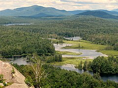 Bog River Flow from Low's Ridge
 -
 Bog River Flow


See also
References
- ^ Jamieson, Paul and Morris, Donald, Adirondack Canoe Waters, North Flow, Lake George, NY: Adirondack Mountain Club, 1987. ISBN 0-935272-43-7
- ^ FindLaw - New York Consolidated Laws
External links
44°07′43″N 74°32′42″W / 44.1287°N 74.5449°W
This article about a location in Hamilton County, New York is a stub. You can help Wikipedia by expanding it. |