
Bonanza Creek
Template:Geobox Bonanza Creek is a watercourse in Yukon Territory, Canada.[1] It runs for about 20 miles (32 km) from King Solomon's Dome to the Klondike River. In the last years of the 19th century and the early 20th century, Bonanza Creek was the center of the Klondike Gold Rush, which attracted tens of thousands of prospectors to the creek and the area surrounding it. Prior to 1896 the creek was known as Rabbit Creek. Its name was changed by miners in honor of the millions of dollars in gold found in and around the creek.[2]
During gold-mining operations, the course of the creek changed drastically. It was heavily developed during the early 20th century, but was largely abandoned by the 1950s. A handful of small gold-mining operations continue on the creek, but today it is best known for its historic value. The government of Canada has established a historic site centered on one of the gold dredges brought in during the mining years.[3]
Gallery
-
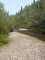 Discovery Claim at Bonanza Creek
 -
 Discovery Claim at Bonanza Creek
 -
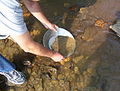 Gold panning at Bonanza Creek
.JPG)
.JPG)

See also
References
- ^ Cite error: The named reference
NRCwas invoked but never defined (see the help page). - ^ Tourism Yukon. "Skookum Jim Mason", Travelyukon.com. 2008. Accessed May 12, 2009.
- ^ Parks Canada. "Dredge No. 4 National Historic Site of Canada", pc.gc.ca. November 28, 2008. Accessed May 12, 2009.
This article about a Yukon location is a stub. You can help Wikipedia by expanding it. |