Bouée
Appearance
Bouée | |
|---|---|
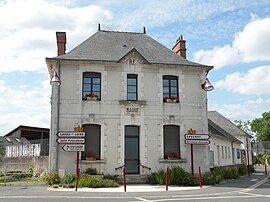
 The town hall in Bouée | |
| Coordinates: 47°19′18″N 1°54′31″W / 47.3217°N 1.9086°W | |
| Country | France |
| Region | Pays de la Loire |
| Department | Loire-Atlantique |
| Arrondissement | Saint-Nazaire |
| Canton | Blain |
| Intercommunality | Loire et Sillon |
| Government | |
| • Mayor (2008–2014) | Claude Rousseaux |
| Area 1 | 21.34 km2 (8.24 sq mi) |
| Population (2009) | 840 |
| • Density | 39/km2 (100/sq mi) |
| Time zone | UTC+01:00 (CET) |
| • Summer (DST) | UTC+02:00 (CEST) |
| INSEE/Postal code | 44019 /44260 |
| Elevation | 0–28 m (0–92 ft) |
| 1 French Land Register data, which excludes lakes, ponds, glaciers > 1 km2 (0.386 sq mi or 247 acres) and river estuaries. | |
Bouée is a commune in the Loire-Atlantique department in western France.
Population
| Year | Pop. | ±% |
|---|---|---|
| 1793 | 762 | — |
| 1800 | 877 | +15.1% |
| 1806 | 877 | +0.0% |
| 1821 | 856 | −2.4% |
| 1831 | 918 | +7.2% |
| 1836 | 890 | −3.1% |
| 1841 | 877 | −1.5% |
| 1846 | 910 | +3.8% |
| 1851 | 921 | +1.2% |
| 1856 | 924 | +0.3% |
| 1861 | 887 | −4.0% |
| 1866 | 891 | +0.5% |
| 1872 | 896 | +0.6% |
| 1876 | 909 | +1.5% |
| 1881 | 876 | −3.6% |
| 1886 | 833 | −4.9% |
| 1891 | 846 | +1.6% |
| 1896 | 818 | −3.3% |
| 1901 | 800 | −2.2% |
| 1906 | 759 | −5.1% |
| 1911 | 722 | −4.9% |
| 1921 | 622 | −13.9% |
| 1926 | 638 | +2.6% |
| 1931 | 591 | −7.4% |
| 1936 | 589 | −0.3% |
| 1946 | 569 | −3.4% |
| 1954 | 527 | −7.4% |
| 1962 | 525 | −0.4% |
| 1968 | 455 | −13.3% |
| 1975 | 435 | −4.4% |
| 1982 | 571 | +31.3% |
| 1990 | 618 | +8.2% |
| 1999 | 661 | +7.0% |
| 2006 | 807 | +22.1% |
| 2009 | 840 | +4.1% |
See also
References
Wikimedia Commons has media related to Bouée (Loire-Atlantique).


