
Boxiron, Maryland
Boxiron, Maryland | |
|---|---|
 Boxiron | |
| Coordinates: 38°06′54″N 75°20′57″W / 38.11500°N 75.34917°W | |
| Country | United States |
| State | Maryland |
| County | Worcester |
| Elevation | 16 ft (5 m) |
| Time zone | UTC-5 (Eastern (EST)) |
| • Summer (DST) | UTC-4 (EDT) |
| ZIP code | 21829 |
| Area code(s) | 410, 443, and 667 |
| GNIS feature ID | 588622[1] |
Boxiron is an unincorporated community in Worcester County, Maryland, United States.[1] Boxiron is located at the intersection of Boxiron Road and Cherrix Road southeast of Snow Hill.
References
Municipalities and communities of Worcester County, Maryland, United States | ||
|---|---|---|
| City | 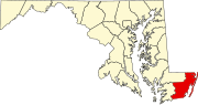 | |
| Towns | ||
| CDPs | ||
| Other communities | ||
| Footnotes | ‡This populated place also has portions in an adjacent county or counties | |