Boyes, Montana
Appearance
45°16′05″N 105°01′52″W / 45.268042°N 105.031090°W
Boyes, Montana | |
|---|---|
 | |
| Country | United States |
| State | Montana |
| County | Carter |
| Time zone | Mountain (MST) |
| • Summer (DST) | MDT |
| Area code | 406 |
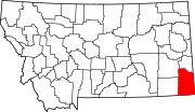
Boyes is an unincorporated community in southwestern Carter County, Montana, United States. It lies along U.S. Route 212 southwest of the town of Ekalaka, the county seat of Carter County.[1] Its elevation is 3,330 feet (1,015 m), and it is located at 45°16′5″N 105°1′52″W / 45.26806°N 105.03111°W (45.2680420, -105.0310901).[2] Although Boyes is unincorporated, it has a post office, with the ZIP code of 59316.[3]
References
- ^ Rand McNally. The Road Atlas '08. Chicago: Rand McNally, 2008, p. 61.
- ^ U.S. Geological Survey Geographic Names Information System: Boyes, Montana
- ^ Zip Code Lookup

