Brčko corridor

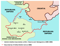
The Brčko corridor (also known as the Serbian corridor[1][2][3]) is a name used for a narrow strip of land along the southern bank of the Sava river that connected eastern and western part of the Republika Srpska from 1992 to 2000. It was created in 1992, after military Operation Corridor and was an important military and civil supply line for western parts of the Republika Srpska and Republic of Serbian Krajina during the Bosnian and Croatian war. After the Dayton Agreement was signed in 1995, the corridor remained within Republika Srpska, but subsequent international arbitration assigned this territory to a newly formed Brčko District (created in 2000), that became a territorial condominium shared between the Republika Srpska and the Federation of Bosnia and Herzegovina.
References
- ^ Applied economics letters. Vol. 7. Chapman & Hall. 2000. p. 327.
- ^ Viktor Meier (1999). Yugoslavia: a history of its demise. Routledge. p. 210.
- ^ Anton Gosar; Vida Rožac-Darovec; Miha Staut (2005). Globalized Europe. Univerza na Primorskem, Znanstveno-raziskovalno središče, Založba Annales. p. 167.
