
Brantley, Alabama
Brantley, Alabama | |
|---|---|
Town | |
 Brantley in 2012 | |
| Nickname: "Front Porch Capital of the South" | |
 Location of Brantley in Crenshaw County, Alabama. | |
| Coordinates: 31°35′3″N 86°15′23″W / 31.58417°N 86.25639°W | |
| Country | United States |
| State | Alabama |
| County | Crenshaw |
| Area | |
| • Total | 3.16 sq mi (8.18 km2) |
| • Land | 3.11 sq mi (8.05 km2) |
| • Water | 0.05 sq mi (0.13 km2) |
| Elevation | 295 ft (90 m) |
| Population (2010) | |
| • Total | 809 |
| • Estimate (2017)[2] | 788 |
| • Density | 253.62/sq mi (97.92/km2) |
| Time zone | UTC-6 (Central (CST)) |
| • Summer (DST) | UTC-5 (CDT) |
| ZIP code | 36009 |
| Area code | 334 |
| FIPS code | 01-09016 |
| GNIS feature ID | 0154995 |
| Website | www |
Brantley is a town in Crenshaw County, Alabama, United States. At the 2010 census the population was 809.[3] Brantley was incorporated in 1891.
Geography
Brantley is located in southern Crenshaw County at 31°35'4" North, 86°15'24" West (31.584365, −86.256651).[4]
According to the U.S. Census Bureau, the town has a total area of 3.16 square miles (8.18 km2), of which 3.11 square miles (8.05 km2) is land and 0.050 square miles (0.13 km2), or 1.60%, is water.[3] The town is located on high ground north of the Conecuh River.
Demographics
| Census | Pop. | Note | %± |
|---|---|---|---|
| 1900 | 390 | — | |
| 1910 | 803 | 105.9% | |
| 1920 | 702 | −12.6% | |
| 1930 | 1,053 | 50.0% | |
| 1940 | 1,126 | 6.9% | |
| 1950 | 1,102 | −2.1% | |
| 1960 | 1,014 | −8.0% | |
| 1970 | 1,066 | 5.1% | |
| 1980 | 1,151 | 8.0% | |
| 1990 | 1,015 | −11.8% | |
| 2000 | 920 | −9.4% | |
| 2010 | 809 | −12.1% | |
| 2017 (est.) | 788 | [2] | −2.6% |
| U.S. Decennial Census[5] 2013 Estimate[6] | |||
As of the census[7] of 2000, there were 920 people, 406 households, and 261 families residing in the town. The population density was 291.1 people per square mile (112.4/km2). There were 467 housing units at an average density of 147.8 per square mile (57.1/km2). The racial makeup of the town was 59.35% White, 40.22% Black or African American and 0.43% Native American. 0.11% of the population were Hispanic or Latino of any race.
There were 406 households out of which 28.8% had children under the age of 18 living with them, 38.2% were married couples living together, 23.2% had a female householder with no husband present, and 35.5% were non-families. 34.5% of all households were made up of individuals and 19.7% had someone living alone who was 65 years of age or older. The average household size was 2.27 and the average family size was 2.90.
In the town, the population was spread out with 24.9% under the age of 18, 5.9% from 18 to 24, 27.0% from 25 to 44, 21.5% from 45 to 64, and 20.8% who were 65 years of age or older. The median age was 40 years. For every 100 females, there were 73.3 males. For every 100 females age 18 and over, there were 63.7 males.
The median income for a household in the town was $21,574, and the median income for a family was $30,078. Males had a median income of $26,063 versus $20,000 for females. The per capita income for the town was $14,108. About 18.8% of families and 24.6% of the population were below the poverty line, including 33.5% of those under age 18 and 25.6% of those age 65 or over.
Education
Brantley Public Schools are part of the Crenshaw County School District. Schools in the district include Luverne High School, Highland Home School and Brantley High School.
Dr. Boyd English is the superintendent .[8]
Confederate monument
In August 2017, a new Confederate monument was installed in the Confederate Veterans Memorial Park in Brantley.[9]
Gallery
-
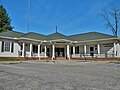 Brantley Municipal Building and Mary Moxley Weed Public Library
 -
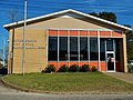 Brantley Post Office (ZIP code: 36009)
 -
 Brantley Fire Department
 -
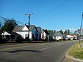 Brantley Historic District was placed on the National Register of Historic Places on June 2, 2004.


Climate
The climate in this area is characterized by hot, humid summers and generally mild to cool winters. According to the Köppen Climate Classification system, Brantley has a humid subtropical climate, abbreviated "Cfa" on climate maps. [10]
| Climate data for Brantley, Alabama | |||||||||||||
|---|---|---|---|---|---|---|---|---|---|---|---|---|---|
| Month | Jan | Feb | Mar | Apr | May | Jun | Jul | Aug | Sep | Oct | Nov | Dec | Year |
| Mean daily maximum °C (°F) | 14 (58) |
17 (62) |
21 (69) |
26 (79) |
29 (85) |
33 (91) |
34 (93) |
33 (92) |
31 (88) |
26 (79) |
21 (70) |
17 (62) |
25 (77) |
| Mean daily minimum °C (°F) | 0 (32) |
2 (35) |
5 (41) |
10 (50) |
14 (57) |
18 (64) |
20 (68) |
19 (67) |
17 (62) |
9 (49) |
4 (40) |
1 (34) |
10 (50) |
| Average precipitation cm (inches) | 13 (5) |
13 (5.2) |
16 (6.3) |
12 (4.8) |
10 (4.1) |
11 (4.4) |
15 (6) |
14 (5.4) |
11 (4.2) |
5.8 (2.3) |
8.9 (3.5) |
12 (4.9) |
142 (56.1) |
| Source: Weatherbase [11] | |||||||||||||
References
- ^ "2017 U.S. Gazetteer Files". United States Census Bureau. Retrieved July 7, 2018.
- ^ a b "Population and Housing Unit Estimates". Retrieved March 24, 2018.
- ^ a b "Geographic Identifiers: 2010 Demographic Profile Data (G001): Brantley town, Alabama". U.S. Census Bureau, American Factfinder. Retrieved June 10, 2014.
- ^ "US Gazetteer files: 2010, 2000, and 1990". United States Census Bureau. February 12, 2011. Retrieved April 23, 2011.
- ^ "U.S. Decennial Census". Census.gov. Archived from the original on May 12, 2015. Retrieved June 6, 2013.
{{cite web}}: Unknown parameter|deadurl=ignored (|url-status=suggested) (help) - ^ "Annual Estimates of the Resident Population: April 1, 2010 to July 1, 2013". Retrieved June 3, 2014.
- ^ "American FactFinder". United States Census Bureau. Archived from the original on September 11, 2013. Retrieved 2008-01-31.
{{cite web}}: Unknown parameter|deadurl=ignored (|url-status=suggested) (help) - ^ "Crenshaw County Schools". Crenshaw County Schools. Retrieved June 20, 2012.
- ^ Johnson, Alex (August 28, 2017). "A New Confederate Monument Goes Up in Alabama". NBC News. Retrieved August 29, 2017.
- ^ Climate Summary for Brantley, Alabama
- ^ "Weatherbase.com". Weatherbase. 2013. Retrieved on November 3, 2013.
External links
31°35′04″N 86°15′24″W / 31.584365°N 86.256651°W
Municipalities and communities of Crenshaw County, Alabama, United States | ||
|---|---|---|
| Cities | 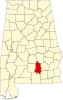 | |
| Towns | ||
| Unincorporated communities | ||
| Footnotes | ‡This populated place also has portions in an adjacent county or counties | |