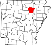
Bryant, Independence County, Arkansas
Appearance
- See also: Bryant, Saline County, Arkansas.
Bryant, Arkansas | |
|---|---|
| Coordinates: 35°44′30″N 91°39′08″W / 35.74167°N 91.65222°W | |
| Country | |
| State | |
| County | Independence |
| Township | McHue |
| Elevation | 509 m (1,670 ft) |
| Time zone | UTC-6 (Central (CST)) |
| • Summer (DST) | UTC-5 (CDT) |
| Area code | 870 |
| GNIS feature ID | 57458 |
| U.S. Geological Survey Geographic Names Information System: Bryant, Independence County, Arkansas | |
Bryant, Arkansas is an unincorporated community in McHue Township, Independence County, Arkansas, United States.[1] It is located on Arkansas Highway 25 south of Batesville.[2]
References
- ^ "Feature Detail Report for: Bryant, Arkansas." USGS. U.S. Geological Survey Geographic Names Information System: Bryant, Independence County, Arkansas Retrieved December 6, 2010.
- ^ Arkansas Atlas and Gazetteer (Map) (Second ed.). DeLorme. § 35.


